Google Maps Aid Public Transit in Three U.S. Cities
By Cynthia Herbert :: 10:22 PM
 Three cities will benefit from transit data integrated into Google Maps, as the search giant announced today that it is adding live public transit information to Maps for New York City, Washington, D.C., and Salt Lake City.
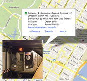
Google Maps users will now have access to some subway and bus departure times for New York and Salt Lake City and service alerts for the Metrorail in Washington, D.C.
Seven New York City subway lines (1, 2, 3, 4, 5, 6, and 42nd Street Shuttle) have live subway departure times reflected on the Maps, as do several tram and bus lines in Salt Lake. While Washington D.C.’s Metrorail doesn’t have live departure information yet, it does provide service alerts, delay notifications, and notices of scheduled track work for users.
“We want to make sure you have access to the most comprehensive, accurate, and useful information when you’re on the go — and that includes public transportation,” said Soufi Esmaeilzadeh, Google Maps development manager. “With these updates — part of the millions of live transit schedule updates we process every day — you get instant access to the latest information right on Google Maps, making trip planning a cinch.”
Google has transit data for 800 cities across 25 countries. This data includes route maps, stops and pick-up locations, fare information, and estimated travel times. The company has been working on transit mapping for 5 years, and started by mapping New York City’s transit system in 2008.