Etch Creates Printed Map of Your Foursquare Checkins
By Gilbert Falso :: 4:19 PM
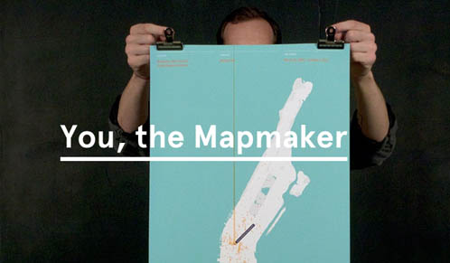
A new service from a company called Etch allows Foursquare users to customize and print out large format maps of their check-ins in several select U.S. cities.
Etch will synch directly with a Foursquare account to download data for check-ins in Manhattan, Portland, or San Francisco. Users can customize the map with a choice of three color schemes, and highlight a particular venue on the map through a special callout flag.
The company calls the maps “one-of-a-kind city maps. They’re data visualizations of your Foursquare check-ins, your unique story of exploring your favorite cities.”
After your map is customized, Etch prints it out for $48, plus shipping. Maps vary in size between 18 and 22 inches wide and are all 26 inches high. The company says they are suitable for framing, and considers them to be more works of art than novelties.
This service is the latest use of Foursquare’s massive treasure trove of personalized data. Earlier this year, the location-based social network launched a tool called “Your Year in Check-ins” that displayed user check-ins as a round graphic showing locations most frequented, along with user paths from one location to another.
It is not clear when additional cities will be added to Etch’s menu – the company says that they plan to add more cities in the future, both domestic and international, but will base the decision on the feedback that they receive from users. Given Foursquare’s initial launch in Austin during SXSW a few years ago, that Texas city could be a good possibility for a future location.
Right now, Etch is only plotting check-ins that use Foursquare’s service, but is open to recommendations for other location-aware services that can also provide data to plot to a map.
[Etch]