Google Maps Car Caught Speeding in School Zone
By Paul Thomson :: 10:09 PM
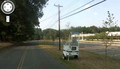
The photo above is a screen capture from a Google Maps image, taken as the Google Maps car drove by an automated police radar trailer in Granby, Connecticut.
Snapped in 2007, the photo shows the display of the radar trailer reading 36 MPH, with the speed limit sign for the road listed at 30 MPH. Probably a slight speeding infraction for the Google Maps car, but certainly not an egregious error.
The incident was first noticed by Reddit user pntbaler154 earlier today, and posted to the site. Other Reddit users quickly got to work and confirmed the legitimacy of the image, and provided the Google Maps link as evidence. The building immediately to the right of the road and radar trailer is Wells Road Elementary School.
To be fair to the Google Maps car driver, it was only 6 miles over the limit, the road was clear and dry, and there were no children present in the picture. The shadows cast by nearby trees suggest the photo was taken in late evening, long after school had let out for the day.
[Google maps link]